
Natural Landscapes from the Arab World
مَناظِر طَبيعِيّة من العالَم العَرَبيّ
1. Natural landscapes مناظر طبيعية
Click on this link to see which natural landscapes مَناظِر طَبيعِيّة you think come from the Arab World.
2. Seas, Oceans and Coastlines البحار والمحيطات والسواحل
The Arabic expression منَ المُحيط إلى الخَليج (“from the ocean to the gulf” meaning the Atlantic Ocean المُحيط الأطْلَسيّ to the Arab/Persian Gulf الخَليج العَرَبيّ) is commonly used to designate the borders of the large and geographically diverse expanse that makes up the Arab World العالَم العَرَبيّ. The vast coastal line السّاحِل of the Arab World actually extends over six major water bodies in the world: the Atlantic Ocean المُحيط الأطْلَسيّ, the Mediterranean Sea البَحْر الأبْيَض المُتَوَسِّط, the Red Sea البَحْر الأحْمَر, the Arabian/Persian Gulf الخَليج العَرَبيّ, the Arabian Sea بَحْرالعَرَب and the Indian Ocean المُحيط الهِنديّ.
On this extensive coast line lie some of the most beautiful beaches شَواطِئ in the world. The beach شاطِئ of Alexandria الإسْكَنْدَريّة in Egypt مِصْر, and the beaches of the Red Sea البَحْر الأحْمَر and the Mediterranean البَحْر الأبْيَض المُتَوَسِّط are some of the most celebrated of the region.
3. Deserts and Oases الصحاري والواحات
It is not surprising that the natural landscape that is most associated with the Arab World is that of the desert صَحْراء. The Arab World holds the top two largest deserts صَحارٍ of the world: the North African desert and the Arabian desert. The North African desert, also known as the Sahara desert الصَّحْراء, is the largest in the world and spans a land mass that is slightly bigger than the United States. The Sahara desert spreads both over Arab and non-Arab African countries. On the eastern shore of the Red Sea, lies the Arabian desert صَحْراء العَرَب, the second largest desert in the world with its famous Empty Quarter الرُّبْع الخالي, the great sand desert of southern Arabia. Both deserts host spectacular oases واحات such as the one in Siwa سيوا, Egypt مصر.
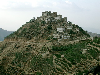
4. Mountains and Valleys الجبال والوديان
In addition to its massive Sahara, the countries of North Africa شَمال إِفْريقيا, particularly Algeria الجَزائر and Morocco المَغْرب are known for their impressive mountain range Another renowned mountainous region in the Arab World is located in Lebanon لُبْنان. With its breathtakingly majestic views, mountain villages, and ski resorts, Mount Lebanon جَبَل لُبْنان remains Lebanon’s best known natural landmark. Before the Civil War, this mountain attracted many Arab tourists escaping the summer heat in other Arab countries. Some still nostalgically refer to the (mythical) Lebanon of that era as the “ Switzerland of the (Middle) East”: سُويسْرا الشَّرق. Click here to view a map of Lebanon. In the Arabian Peninsula, Yemen and Oman comprise the highest elevations of the region as well as its deepest valleys وادٍ ج. وِديان. |
5. Plains and Forests السهول والغابات
With humble elevations compared to those found in Morocco or Lebanon, Tunisia managed to distinguish itself across the Arab World as تونِس الخَضْراء “Green Tunisia”. Tunisia may have earned this flattering nickname thanks to the surviving strip of oak tree forests غابات الفِلّين that stretch over the northwestern tip of the country along the Mediterranean coast into Eastern Algeria. Known in Roman times as the “breadbasket of Rome,” Tunisia may have earned this as تونِس الخَضْراء attribute because of its partly irrigated fertile plains سُهول covered with citrus fruit trees and wheat in the North, olive groves along the coast ساحل and its oases واحة filled with date producing palm trees in the south.
6. Rivers الأنْهار
Moving east in the Arab World, the Nile river نَهْرالنّيل, the longest river نَهْر in the world, has nurtured the fertile lands of Egypt مصر and Sudan السّودان since ancient times. Along the shores of this river where the civilization of the Pharaohs once thrived now stand Cairo القاهرة, the capital of Egypt and the largest city in the Arab World, as well as Khartoum الخُرْطوم, the capital of Sudan.
As a natural resource that sustained the growth of major civilizations in the region, the Nile is only rivaled by the rivers Tigris دِجْلة and Euphrates الفُرات which flow along the furthest Northeastern part of the Arab world, namely Iraq and Syria. The fertile plains سُهول watered by دِجْلة والفُرات supported centuries of Islamic civilization at its apogee and constituted the heartland of historical Mesopotamia بِلاد ما بَيْنَ النَّهْرَيْن, literally “the land between the two rivers.”
Rain, a valuable commodity in the arid areas of the Arab world, has many names. Perhaps مَطَر is one of the most commonly used names. Rain is also referrred to as خَيْر, meaning roughly blessing or bounty, in appreciation of its value to life.
Please refer to the Culture Vocabulary.